ST. CHARLES COUNTY HISTORY

By Dorris Keeven-Franke

  • Original Plat of Saint Charles

    And the Story of an Old Map

    Everyone loves old maps. They do a lot more than give directions. Historic maps can share what a place looked like at a certain point in time and transport us back to another era. There are some maps can do more – they can share a story as well (like a Story Map – see below) This is the story of a map that takes people back in time, to the City of St. Charles historic past, all the way back to its’ original plat.

    A few years ago, while working as archivist at the St. Charles County Historical Society in 2011, a crinkled and faded was found. The secretary at that time, Cleta Flynn, was introducing me to some of the more reclusive collections tucked away in corners of the historic building, the City’s original Market House. Saying “if you like old maps, this large map case has a lot of interesting old ones.” I found one that was taped, creased, folded and flattened (something us archivists hate) that appeared to have not seen daylight in a hundred years – which was good for the map – but rather sad.

    map

    Keeping the old map handy for the next few years, it would be used for study from time to time. Trying to unlock its secrets, the map did not appear to have any date on it, nor did it have a signature to recognize who had drawn this treasure trove of information. Realizing it was a map of St. Charles, and that it was old (which could be recognized by its ink and paper) we ( Cleta Flynn, volunteer Jim Peine, and all of the SCCHS Volunteers) became determined to learn more. It was old, but just how old? And who had drawn it? And why? What was its’ purpose and who was the information for? This wasn’t a Google map to be used for directions. This would permanently establish the City of St. Charles.

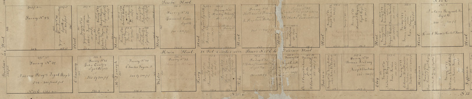
    The map clearly laid out St. Charles as a grid of streets and cross streets, giving their names. The street names were old and historic – Barbour, Chauncey, Pike and Clay. Over the years we would pull the map out whenever a researcher needed information about early St. Charles. The names of the owners in each of these blocks became very important. It became obvious that if we were to know just when the map was made, perhaps knowing when the owners should be found on such a map, we could possibly discern a date. And so every time we were able, we used the map, taking great care.

    Finally we were able to pin the map down to the era of circa 1817, give or take a few years. That is when knowing its importance and wanting to make certain of its preservation, the map was sent off for conservation by Lisa Fox, Head Conservator at the Missouri State Archives at that time. She and her wonderful team worked their magic, carefully removing the old tape, creases, and dirt to reveal an even more magical piece of history. The map, approximately fourteen by seventy-two inches was then digitized in order to enable everyone to delve into its history.

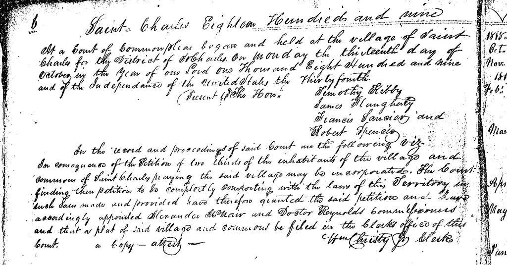
    Because of this great work, the map is carefully preserved, yet made available to everyone (in 2013). Since then, I wanted to know more of the maps other great mysteries. Who was its’ creator and why? Sometimes, when trying to discover the stories found in old documents and maps, you have to travel to the time in which the people lived. So I went to the City’s Record Book A and on Page 8 found this:

    Authorizing and ordering the limits of the Town of St. Charles to be estendd [sic] according to the original plan of said town and providing for and ordering a certain proportion of the town commons to be surveyed and divided into lots and regularly numbered which saw lots so surveyed and numbered, together with the Town lots as Extended surveyed & numbered were ordered to be Leased at public sale by the Clerk of the board on the 10th day of September 1821.

    City Council Book A Page 8
    City of St. Charles Minutes, Book A, Page 8 Microfilm Reel 977.839 Kathryn Linnemann Library

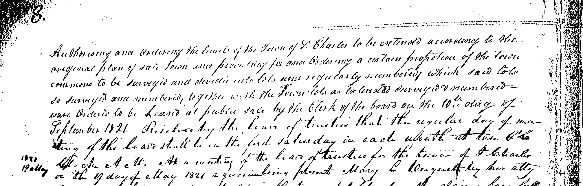
    Up until 1818, they had been working with a map drawn by Soulard, according to their Minutes. Then there is a bit of a gap,  and then is the above entry. As they immediately start selling and leasing these additional lots, which are NOT shown on this map, this indicates that this map is perhaps the one they started with. During this same time period, they have also employed the surveyors Prospect K. Robbins and Nathan Boone. Five pages later, Prospect K. Robbins is paid $20 for surveying completed on the 18th of  September 1821. Both Robbins and Boone had worked together before, as a 3 man team was needed – Chain man, Link Man and Surveyor. The third team member may have been James Findley who had settled in Troy when it was founded, as early deeds for this same time period refer to a map made by Findley.

    And as you begin to understand the history, the next question becomes “why?” The old map that I was using told me a)the layout of the streets and gave a name and a survey number of the owners of the land. It told me about people who owned land in St. Charles. St. Charles had just become the temporary State Capitol and people were flooding in. The names of the streets running parallel to the Missouri River are Main, Second, High and Fourth. The cross streets run from Barbour, which is the original southern city limits to Tecumseh Street on the north. Buildings are not shown, and the land measurement used is the old French foot. The name of the owner, if the lot is owned by someone other than the City, is referred to as a survey number in a personal Surveyor’s book, which I never located.

    When the map was restored and processed by the Missouri State Archives conservator in 2013, the dates I had suggested of circa 1820 were also confirmed in their examination of the paper and ink used. Lynn Morrow, with the Missouri State Archives had examined the map before retiring that year. He also suggested that a friend of his in St. Charles, Robert Myers, might be able to shed more light on the mysteries of the old map. When Robert and I met, I took along a copy of “the map”. When the map had been returned to the Archives, I had obtained a print copy for my own research at the same time I had had one made for the Society. Mine has since become well traveled.

    Seeing “the old map” Myers asked “if I had ever seen the map in the City offices?” to which I responded no. Formerly Myers had worked for the City of St. Charles and worked for St. Charles County at that time. He graciously set up an appointment for me to see this other map, and where I would also meet Chuck Lovelace who works for the City of St. Charles. Not knowing what to expect, I was totally shocked when I was shown a framed copy of another very old map that was almost identical! And it had a seal that attested to being a true and authentic hand drawn (in 1871) copy of “The Original Plat of the City of St. Charles”.While this new map discovered is wonderful with much darker ink, and even more information, it was further confirmation of the first map’s identity. The information on this map, matched exactly, block by block. This was the Original Plat, perhaps a working copy for the surveyor, although which one drew it we don’t know yet.

    Working to compare the handwriting of Auguste Chouteau, Antoine Soulard, Nathan Boone, Prospect Robbins and Joseph Evans (who did receive $50 from the City on July 13, 1822 for surveying) has not yet provided an “aha!” moment yet. The closest so far are Nathan Boone and Prospect Robbins.

    This map transports us back to town of St. Charles that has emerged from the early settlement founded by Louis Blanchette in 1769. It has grown past its territorial days as a fur traders outpost, and reached a new glory as important State figures walk these same streets we do today. These people were important in that day as the street names affirm: Barbour, Pike, Clay, Madison and Jefferson. There is so much to yet be learned.

    If you would like to know more of Historic St. Charles Main Street, the most historic Main Street in St. Charles County, and I believe in Missouri, then you can use the link below, for a STORY MAP of St. Charles Main Street. There you will find 150 stories of each building on Main Street represented by a dot on a map. If you use the link on your phone, or download or bookmark the link (depending on how your phone handles these things) then you can actually stand in front of a building and hit the dot for that address, and read its story. Here is the link: https://arcg.is/1qqHzn0

    If you would like to receive an email each day sharing the history of St. Charles County (for free) then enter your email below. These are not shared and there are no passwords involved.

  • The Boone’s Lick Road

    Category: Places

    When Americans declared themselves independent of Great Britain in 1776, there were three settlements west of the Mississippi, Ste. Genevieve, Saint Louis, and San Carlos. In 1763, Saint Louis had been established on the south side of the great Missouri River, creating what would later become the “Gateway to the West”. Shortly afterwards, in 1769, a French-Canadian fur trader named Louis Blanchette, would establish himself in what was then called “Les Petite Cotes” or the little hills. These hills were the mounds created by the indigenous people that had been living here, for centuries. Travel between St. Louis and San Carlos, followed one of either two pathways, by river or overland. When traveling westward overland, pathways became established, that were ones of the least resistance, which the buffalo and other animals had already discovered. The earliest people, such as the Osage, would follow these same pathways, and establish would be called a “trace”.

    As the population increased, so did the use of these early pathways. The first residents were fur traders, who knew that they were leaving the protection of United States but chose to live among the indigenous nations of Osage, Pottawatomie, Sioux and Fox. The land itself though had remained under the flags of the French and the Spanish, being traded first in 1769, and then again in 1799. That year, the well-known trailblazer Daniel Boone, would settle along the Missouri River, south of San Carlos, otherwise known as Saint Charles. Many of those who followed him, were from Kentucky, a State carved from Virginia in the 1770s. These large families brought with them, an enslaved population, that lived under rules known as the Code Noir, or Black Code. All the while, the indigenous population was growing as well, as many were being pushed westward, because of settlement in the Ohio valley. The land was being eyed.  So that when the territory was purchased in 1804, there was already a large population.

    In 1804, as President Thomas Jefferson commissioned a Corps under the command of Captains Meriwether Lewis and William Clark, the Morrison family would establish themselves on the Rue de Grande, later known as Main Street, in St. Charles. The family had been on the leading edge coming from Philadelphia and had already established outposts for trade in Cincinnati and Kaskaskia. William Morrison, and his younger brother Jesse, were cousins to the Boone family, through Daniel’s wife, the former Rebecca Bryan, and would establish Bryan and Morrison at the northern landing on the Missouri River. A pathway had already been established from Saint Louis to Saint Charles, which was referred to as the St. Charles Road. However, it was salt lick referred owned by the Morrisons in partnership with Daniel Boone’s sons Nathan and Daniel Morgan, that gave its name to the region further west, the Boone’s lick.

    STATE HISTORICAL SOCIETY OF MISSOURI

    Salt was one of the most valuable commodities necessary in 1804. Needed not only for curing and preserving their meat but used in tanning furs as well. The beaver, bear and buffalo furs were rendered not only into the fashions of the time but worn by all. Salt was manufactured by boiling water originating from a saltwater spring, a tedious, difficult and often dangerous process. The Bryan and Morrison salt lick had been discovered by the Boone family earlier and was the largest in its’ day. Made even more successful by the generous funds of the Morrison family and the large workforce, many of which were enslaved, that ran the factory 24 hours a day and seven days a week. The salt was packed in bags and crates; and carried downriver on the Missouri River to the landing and the huge stone storehouse to be sold at the Morrison’s mercantile. Supplies and manpower were then carted overland back up to the salt lick, using what became known as the Boone’s Lick trail. No longer just a trace used by the native populations, it was an established trail used by everyone to go westward.

    MISSOURI STATE ARCHIVES

    Documentation of the Boone’s Lick Road comes from many sources. Maps, plats and Surveys, showing early Spanish Land Grants (on an angle) establish when the property was purchased, with deeds going more in depth. Early deeds will quite often establish where the Boone’s Lick Road intersects with a property, or lines its’ border. Early journals are often simple notes, describing the road’s conditions or available lodging. A gazetteer is similar as it just simply gives the local’s name for a place and what is found at that location. Newspapers share postal routes and stagecoach stations, and the distances are helpful to a degree, as property owners and postmasters could often change. Early historians like Kate Gregg bring so much depth and history by adding details about the residents and their activities.]

    A factory for trade had been established with the Osage, named Fort Osage, just west of the salt lick by 1808. The settlement of San Carlos with 100 families, as Lewis and Clark described it in 1804, was incorporated as the Village of St. Charles in 1809. Within a few years, its Territorial Governor Benjamin Howard, would raise two Corps of soldiers, led by both the Boone sons, to control the uprisings that were occurring between the settlers and the earliest residents. What was called the War of 1812 in the east, was simply referred to as the Indian Wars in the U.S.’ Louisiana Territory. The dispute over the control of what had been the native Americans, presided over the residents’ lives for several years, with several homes turned into fortresses, along the Boone’s Lick trail. This in turn established what had once been only a trace, into an actual road, by the end of the hostilities in 1815.

    In 1816, residents along the road, would petition the young Territorial Government to establish this road. They wanted the road surveyed and marked so that everyone could follow it safely. Postal Routes were being established, and they needed the road marked, as competition among the earlier “forts” became Post Offices and Stagecoach stops. Settlement and westward travel were increasing, and the best routes brought the highest returns. By 1817, both Boone brothers had sold out their portion of the partnership to the Morrisons. By 1818, the population had increased tremendously with the end of the hostilities, and they had reached the threshold of 60,000 necessary for Statehood. Emissaries were sent to D.C. wanting admittance. However, as Congress debated the issue of slavery in what was to become Missouri, a debate raged in the territory as to where the Capitol was to become located.

    It would take years, and a Compromise proposed by Kentucky’s statesman Henry Clay, before Missouri would become a state. And when the agreement was reached in 1821, it had been decided that the best location was with 50 miles of the Osage Nation, and along the Missouri River, in what was to become the City of Jefferson. However there not being any suitable building for the Capitol, a temporary location was needed. Saint Charles was chosen by the State’s Constitutional Commission which had been meeting in St Louis, as the location of Missouri’s First State Capitol. The building selected was Peck’s Mercantile, directly across Main Street from Morrison’s mercantile. And the road to reach Morrison’s salt lick and the City of Jefferson was by then called the Boone’s Lick Road. The termination of the road was in Howard County, the fastest growing county in the state, and was where the Santa Fe Trail began. The town of Franklin, in Howard County, in what was simply referred to as the Booneslick, had become the new frontier. 

    The Boone’s Lick Road had become the way west, with thousands using it, establishing Post Offices, then stagecoach stops, which turned from settlements to villages, and then to towns. What had once been simply a trace was now the “Big Road” and the way west.

    The Daughters of the American Revolution (DAR) would work to mark the Boone’s Lick Road in 1913, giving us a tangible reminder and keeping the history of the road alive. Sometimes these markers have been moved or become lost as progress established new roadways. Some locations would not be known today if it were not for the DAR’s efforts to preserve the road’s history and the role it played in our state’s history. Research methodology did not have the availability of records that modern historians have today. These markers still provide a great tour for those who want to follow the road on their own and will be shared throughout this story. All DAR markers noted are taken from the following website: https://viewer.mapme.com/mssdarbooneslick/location/1a5b287e-3a03-4094-af86-fe6bdd1ba865/gallery/1%5D

    When the French-Canadian fur trader, Louis Blanchette, settled along the Missouri River he would refer to his settlement as Les Petite Cotes or ‘the Little Hills’ in an area known for the mounds made by the indigenous people. In the Carte des Etats-Unis de L’Amerique dated 1784, neither they nor the settlement of Saint Louis are indicated. By 1800 it would become known as San Carlos, meaning St. Charles, with it being the terminus of a trail from Saint Louis, as there was no “Boon’s Lick” at that time. In May of 1804, Captains Meriwether Lewis and William Clark would make it their first stop, with their journals stating it had about 100 families living there.  The ‘road’ west that they would travel was called the Missouri River.

    FOR MORE INFORMATION SEE https://www.booneslickroad.org/

    For more stories like this in your email box each day…

  • Establishing the birth of a City

    In 1769, Louis Blanchette settled along a small stream that would later bear his name. A fur trader from a very prominent and wealthy French-Canadian family had struck off to

    Blanchette-Coontz house
    House built on the site of Louis Blanchette’s original settlement in Block 20 on the Original Plat of the City of St. Charles established in 1769

    start a new settlement. The Spanish recognized Blanchette and made him their commandant after they took possesion in 1770.The Census of 1787 of St. Charles… contains the following information about Blanchette “Juan Bapta Blanchet, aged 51; Maria Su Mujer; 48, Baptiste Blanchette 24; Maria Blanchette 21” In addition to these his household contained, one carpenter, one huntsman and four laborers. Houck also quotes Auguste Chouteau, as noted in Hunt’s Minutes Book 1, page 127 saying “was established by Blanchette.” Houck also established where Blanchette lived “the lot upon which the first house being the square now numbered 19 bounded on the south by McDonald [McDonough], west by Main, east by Missouri [River] and north by Water streets, and from this we infer that Blanchette must have first erected his hut on this block when he made a settlement at what is now St. Charles.” In 1789, Louis Blanchette, sold his land in the southern part of the village to John Coontz, a German,… and he too erected a grist mill on Blanchette Creek, building a dam for it on what is now known as Block 79. Romain Dufreine, testifiying before Theodore Hunt, Land Commissioner, on May 7, 1825, swore that John Coontz had built his mill on this square thirty years before, i. e., in 1795, and had continued to occupy the land until he moved to the Dardenne ten or twelve years later. Blanchette died in 1793. Subsequently Charles Tayon was appointed Commandant of the village, and had to petition to the Spanish who literally owned the land, permission for such things as to cut wood in the commons. In 1800, the Treaty of San Idolfonso brought the small village back to a part of the French domain. Spain was unhappy with the treaty, as it did state that France was not to sell the land, which it promptly did in what we call the Louisiana Purchase on April 30, 1803. This was ratified nearly a year later in March of 1804, which is what held up Jefferson’s Corp of Discovery which left Saint Charles on May 21, 1804. At that time there were over a hundred families (about 450 inhabitants) spread primarily along today’s Main Street. The village had grown from 1787 when it had: eighty families to one hundred families. “The houses, about one hundred in number, in which the four hundred fifty inhabitants lived, were scattered along a single street about one mile long” By 1808, the Village is of such importance that the U.S. Government would send its U.S. Army to establish Fort Osage, as Sibley and Clark assembled their men here, they would leave on an established road, formerly called the Osage trace (a well traveled road) that left from in front of the former Blanchette’s house. On July 8, 1808 the U.S. Government, from their headquarters at St. Louis at that time had made laws that established roads, and the local village had begun to petition for a road to the west. The small village had grown to become a young City, westward expansion had begun, and on October 10, 1809, the City of St. Charles was Incorporated so that it was able to establish its own laws, survey and sell its land, and govern the village which had grown to nearly a thousand people already.

    The Incorporation papers say:

    City of St. Charles Record Book A Page 6

    Saint Charles Eighteen Hundred and nine

    At a Court of Common Pleas began and held at the village of Saint Charles for the District of St. Charles on Monday the thirteenth day of October in the Year of our Lord one Thousand and Eight Hundred and nine and of the Independence of the United States the thirty fourth.

    Presnt the Hon. Timothy Kibby

    James Flaugherty

    Francis Saucier and

    Robert Spencer

    In the record and proceedings of said Court we the following viz.

    In conveyence of the Petition of two thirds of the inhabitants of the village and commons of Saint Charles praying the said village may be incorporated. The Court finding then petition to be completely comporting with the laws of this Territory in such laws made and provided have therefore granted the said petition and have accordingly appointed Alexander McNair and Doctor Reynolds Commissioners and that a plat of said village and commons be filed in the Clerks off of this court.

    Wm Christy  for Clerk

    StChasInc

    Enjoying our stories? Get a daily dose of St. Charles history every day!