History happens. All stories, especially the difficult ones, need to be heard. Award winning author, a public historian, professional genealogist, and International speaker. Member of the Missouri Speakers Bureau and the National Underground Railroad Network to Freedom.
Heading westward from St. Charles on the Boone’s Lick Road, one left the village heading west and would pass Old Man Schaffer’s Tavern [on Parkside, today it is a private home and still standing, but there is no marker] who served the needs for those driving their stock to market. Friedrich Schaeffer was a German immigrant who hadmost likely read the Report on a Journey to the Western States of America, published in Germany by Gottfried Duden in 1829 which extolled the virtues of the young state of Missouri. Like thousands who came during the 1830s, the German immigrants would not only change the state’s demographics but its’ history as well. Schaeffer’s Inn was a favorite for those needing a watering hole for their cattle, outside of the town’s limits on what was formerly the Commons. City ordinances did not allow cattle and hogs to roam the streets.
[Proceeding further on Boone’s Lick, turn left/south on Missouri’s State Highway 94/First Capitol and proceed to Mid-Rivers Exit. Turn right/west on Mid-Rivers and proceed until the intersection with County Highway N. Turn left on Highway N ]
COONTZ’ FORT
BOONE’S LICK ROAD MARKER – BY THE DAUGHTERS OF THE AMERICAN REVOLUTION AND THE STATE OF MISSOURI IN 1913 KOUNTZ’ FORT at 4965 Highway N on your right hand side.
Two Coontz brothers had been born in Germany and had perhaps served in the Hessian Militia for the British Army during the Revolutionary War, but defected and joined the colonists. One brother had been captured by the Native Americans and had been presumed dead. The other would come further west and settle in St. Charles purchasing Blanchette’s property from his estate. The first brother had learned of the others whereabouts and joined him in what was then Louisiana Territory. Nicholas Coontz would acquire Survey #58 on 29 Aug 1799. His log home was large enough and well-built and would be fortified to serve as a Fort, for the protection of many of the area families during the War of 1812. He kept a tavern, and in the Memoirs of John Mason Peck, D.D., 1789-1857 he was described as “a rough, wicked and yet hospitable old German”.
Site of the 6 mile house where travelers could stop for water was earlier site of Koonz Fort
PROCEED SOUTH ON HWY N TO COTTLEVILLE, IT IS IMPORTANT TO STAY ON HWY N AS IT MAKES SEVERAL TURNS THROUGH COTTLEVILLE.
COTTLEVILLE
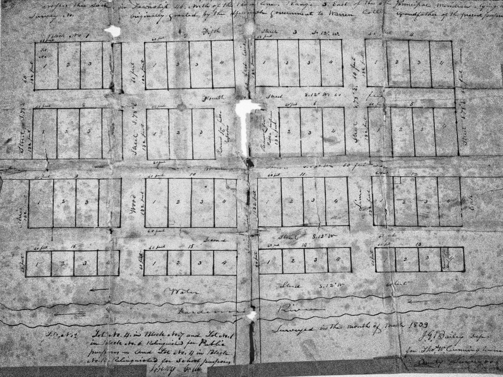
Cottleville’s history as a settlement begins with the occupation of Warren Cottle, Sr. on a plot near Dardenne River (Creek), obtained through Spanish land grants in 1798. Together, with his sons, Warren and Ira, Cottle began a grist mill on the Dardenne River (Creek) in 1799. Cottle’s Mill used waterpower to sift and grind wheat, oats, and other products. The water method proved to be superior to the other horse powered mills found within the area and many people began to bring their harvested crops to Cottle’s Mill. Over the next decade, the large number of customers encouraged the establishment of small shops and lodges to accommodate those waiting, sometimes overnight, for their turn at the mill. The mill was one story high. The power for the mill came from an overshot wheel on the left side of the drop and it had wooden gears. The driving gear had all wooden cog wheels and the frame mill was one story high.[i] In 1837, Cottle would file a plat of his town with the St. Charles County Recorder of Deeds, making it official.
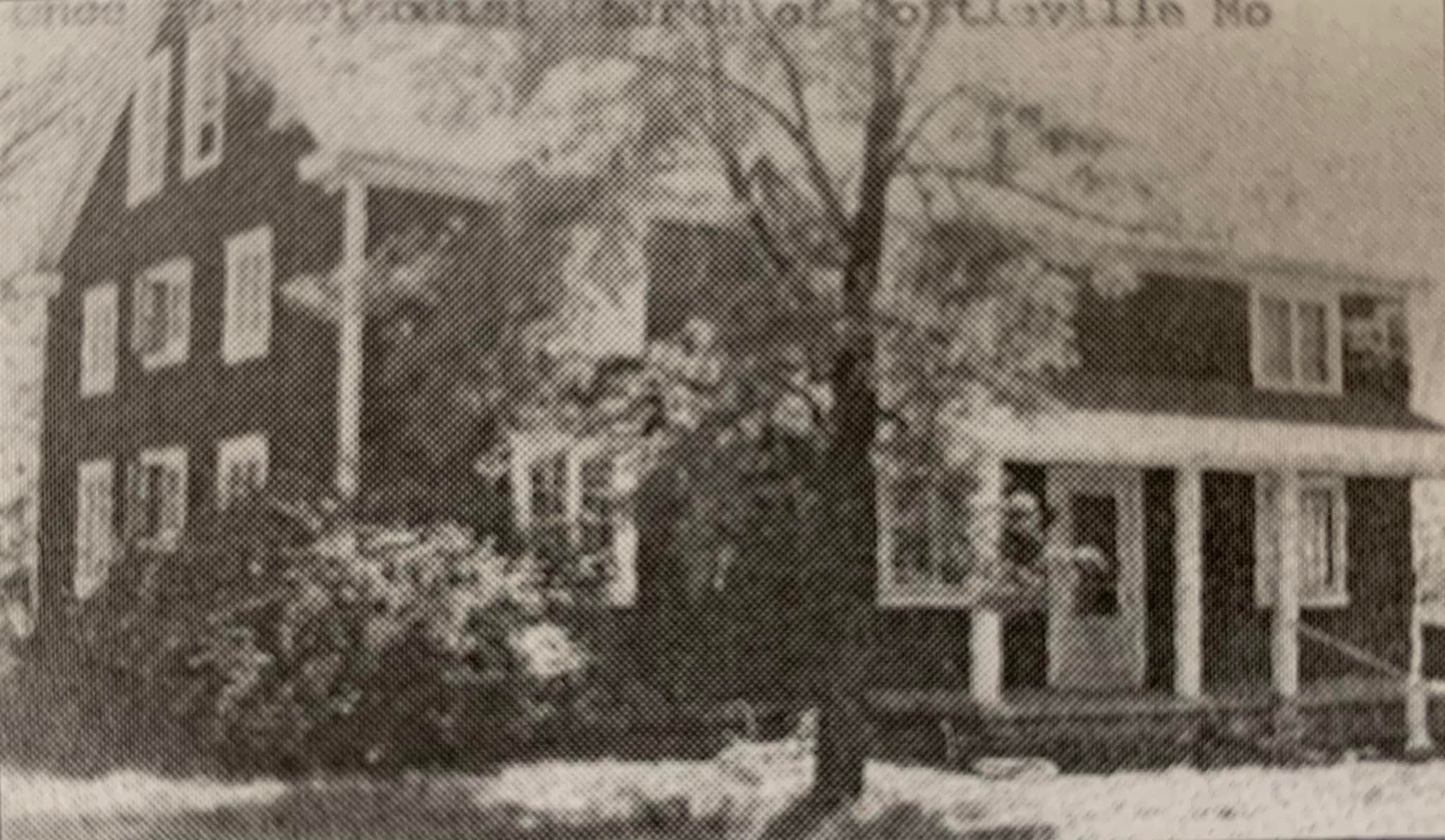
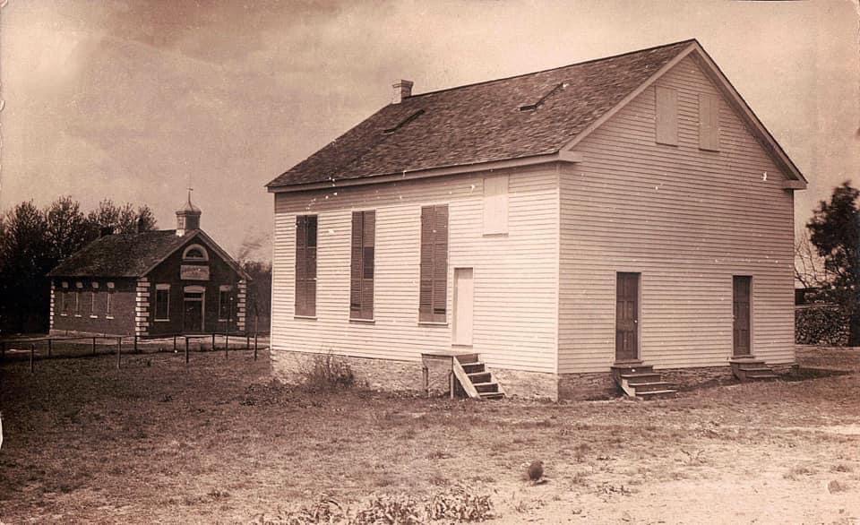
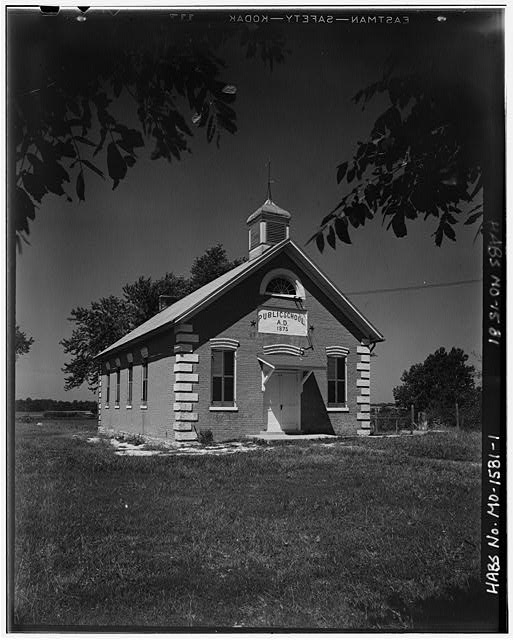
An unidentified Cottleville houseSouthern Methodist Church by Public SchoolOra Cottle home (no longer standing)Original Plat of Cottleville (St. Charles County Recorder of DeedsSouthern Methodist Church as a homeSouthern Methodist Church with Public School in back1905 Atlas of CottlevilleHoffmann house at Hwy 94 and Mid-Rivers Dr.HABS photo of Cottleville Public School
An early undated map in the St. Charles County Historical Society shows that In Lynn Morrow’s Boone’s Lick in Western Expansion: James Mackay, the Boones, and the Morrisons[i]today’s St. Charles County is part of the St. Charles District or county, “the only American political subdivision on the north side of the Missouri River until 1816”.
Unfolding events brought Morgan and Nathan Boone into a commercial salt industry with Philadelphia’s Bryan and Morrison trading company, the most influential American firm in Missouri’s trans-Mississippi West. Of the six Morrison brothers who came West, William, the eldest, administered the family business from Kaskaskia, assigning James, Jesse, nephews, and others to implement their strategic economic reach. Boone’s Lick salt became crucial in the Osage Indian trade, Missouri River commerce, and for support of federal and Missouri militia troops in the War of 1812.[ii] It would be James Morrison who would open the Trading Post on Main Street in 1804 that would sell the product of his salt lick in what is later called “the Boonslick” in Howard County. In 1806 he would supply and outfit Gen. Zebulon Pike (Pike’s Peak) expedition from this storefront.
An early undated map of St. Charles I discovered in 2011in the St.Charles County Historical Society archives gives us a view of the village’s Rue de Grande or Main Street in what is believed to be 1817. When the map was restored and processed by Lisa Fox at the State Archives in 2013, this was confirmed in their examination of the paper and ink used, and by Lynn Morrow, with the Missouri State Archives who had examined the map before retiring that year. It places the Bryan and Morrison trading company between Clay and Madison; Main and Second, with other records indicating that the property had been purchased by Morrison by 1804.
Operators of frontier salines usually owned enslaved and/or leased enslaved to shoulder a lot of the hard, physical work, especially wood chopping, but there are few documents about slaves at Boone’s Lick. In 1814, a Draper informant told about Moses, who in the face of an Indian alarm, rode one of the Morrison horses back to St. Charles. Flanders Callaway’s slave Moses had worked for years up and down the Missouri River, serving the Callaway family in agriculture and market hunting. Moses cut a lot of wood at Boone’s Lick, too.
Across from the Bryan and Morrison Trading Company at 200 South Main Street is Missouri’s First State Capitol.
Circa 1819 – Built by Charles and Ruloff Peck in 1819, this building housed Missouri’s first State Capitol from 1821 until 1826. Missouri’s first legislators – some of them frontiersmen and others of the gentry – met in this building to undertake the task of reorganizing Missouri’s early territorial government into a progressive state system. Before Missouri was granted statehood on Aug. 10, 1821, the territorial government met at various locations in St. Louis. As statehood became a certainty, the search began for a site to become the permanent seat of government. An undeveloped tract of land located in the center of the state overlooking the Missouri River was chosen to be the site of “The City of Jefferson,” Missouri’s permanent capital. However, until the new Capitol could be constructed, the state’s first legislators needed a place to meet. Nine cities competed for the honor of hosting the state’s temporary seat of government. One of these cities was St. Charles, a growing center of trade located on the Missouri River with easy access to the most rapidly growing areas in the state via the river or the Boonslick Road. The citizens of St. Charles pledged that if their city was chosen as the temporary capital, they would furnish free meeting space for the legislators. On Nov. 25, 1820, Gov. Alexander McNair signed a bill making St. Charles the first capital of Missouri. The state’s first legislators met in St. Charles for the first time on June 4, 1821. Heated debates over state’s rights and slavery filled the rooms of the new temporary Capitol. The meeting place provided by the citizens of St. Charles was on the second floor of two newly constructed adjoining Federal-style brick buildings. The Peck brothers, Charles and Ruluff, owned one of the buildings and they operated a general store on the first floor. Chauncy Shepard owned the adjoining building with a carpenter shop on the first floor. The second floor of the building was divided and used as Senate and House chambers, an office for the governor, and a small committee room. Four Missouri governors ran the state’s affairs from the Capitol in St. Charles until the new Capitol in Jefferson City was ready in 1826.[iii]
As one continues south on the City of St. Charles Main Street they will pass:
515 S Main St, Saint Charles, Missouri, 63301
Circa 1821 – Historians confer that this is the site of William Eckert’s St. Charles Hotel in 1821. He and his partners had offered his establishment to the State when they were seeking a site for the Capitol , as a larger and more commodious building. At that time, in 1821, a large stone building was known to have sat to the rear of this building, so perhaps that was the one being offered for the State’s use. Some historians suggest that this building was damaged in the 1876 tornado to such an extent that it was altered to be the building you see today. Eckert’s Tavern was also reported to be where Benjamin Reeves, George C. Sibley and Thomas Mathers, who were appointed as Commissioners in 1825 by President John Quincy Adams, laid out the Sante Fe Trail. This work to establish a route for trade with the southwest and New Mexico, went over budget and took seven years for the three commissioners to receive their pay for this feat. [iv]
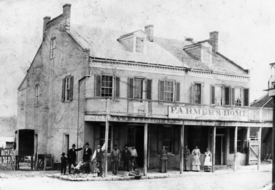
Further south on St. Charles’ Main Street, one encounters other vestiges of Bryan and Morrison’s route to their salt lick. Farmer’s Home is an example of the many inns and mercantiles that line the street…
700 S Main St, Saint Charles, Missouri, 63301
Circa 1805 – In 1817 when Alexander McNair owned this property, he would add on to the earliest portion of the building, keeping the French influence. McNair’s wife was Margarite Regal, the daughter of a French Marquis. In 1820, he defeated William Clark, to become our State’s first Governor. Although he lived in St. Louis with his wife and children, he would stay here when he needed to conduct State business. The building was a tavern, where J.J Dozier the Innkeeper would invite the Legislature and other visitors to the town to stay at the establishment when St. Charles was Missouri’s first State Capitol 1821-1826. At that time the cost of lodging was “2 bits a night (or 25 cents) and you could get Chicken Fixings for 3 bits or 37 and one-half cents”. McNair died on March 18, 1824 while still in office. The building would continue to serve as an Inn, and was always a hub of activity, since visitors would arrive on the nearby ferry and have to pass the Inn on their way to the State Capitol, ensuring its success. At one time the inn was known as the “Bear Sign” and owned by a German named Valentine Schmidt. In 1853 the name according to the St. Charles newspaper named the Reville, was changed to Farmer’s Home and managed by the German innkeeper named Frances Bierbaum. On the 26th of February 1876, the Inn was struck by the great tornado. Stories tell of a man in his bed on the second floor who was picked up and thrown into the street without even being hurt. [v]
When you proceed further south, one will reach the location of Blanchette’s first settlement…
906 S Main St, Saint Charles, Missouri, 63301 (private home)
Circa 1793 – The site of the home of the City of Saint Charles’ founder Louis Blanchette who settled here with his wife and children in 1769. Soon after he was appointed Commandant by the Spanish he built three buildings along the small stream nearby. After his death in 1793, the property was owned by Peter Coontz [Koonz/Kountz], a German, who either added onto Blanchette’s building or built this one with a small primitive mill along Blanchette’s creek. When Louis Tayon had been appointed Commandant for the District and he felt that all of Blanchette’s’ property should by rights be owned by the City and by rights become his under the Spanish Crown. This would later be argued all of the way to Missouri’s Supreme Court, with the Court still finding in favor of the Coontz family. Excavations done by the Archeology Department for Lindenwood University do confirm that there was a building situated here at this location during the time period of Blanchette’s arrival.[vi]
Author Dan Rothwell’s book shares how the original pathway of the Boone’s Lick Road merged with Main Street at this point, which was probably because of early connection with Blanchette as Commandant. Early deeds refer to the southern stretch of Main Street as Upper San Carlos as it was where the seat of Government was prior to the Louisiana Purchase.[vii] But by 1851, one had to continue further south on Main Street before it turned west. There one sees further evidence of what the Boone’s Lick Road meant to travelers at The Western House…
preservationjournal.org
1001 S Main St, Saint Charles, Missouri, 63301
Circa 1820 – Gregorie Kiercereau, born Bebi, was the owner of this property in 1817, and the property across the street to the north indicating that he most likely owned this property prior to that date. Kiercereau was the nephew of the second Commandant Carlos Tayon by marriage. The original structure of the building faces Main Street was built in 1820 with several additions made over the years, with some as late as 1856. During the 1850s, the route of the Boone’s Lick Road, which had begun by the 1820s and had originally left Main Street going west up McDonough, was moved alongside this building. This accounts for the direction of the additions at the rear. The road had been part of the Plank Road system, which was a short-lived paving system which used cut logs forming what was also called a ‘courderoy’. Travelers would often use the logs as firewood though. The city macadamized the road in the 1850s, which is an early gravel and oil method. By that time, Fanny Smith Eckert maintained an inn named Western House here, which was very popular with travelers. An inn was always maintained on the lower floor with sleeping rooms on the upper levels. During the days of the covered wagon treks, a large stable and wagon yard was located in the rear and to the south of the existing building. Later the establishment was conducted by a Mr. Bliss and was considered too rowdy for women and children. The inn provided excellent care to oxen, horses and cattle when Mr. Bliss eventually added a blacksmith shop to provide for care and repair of equipment.
[vii] Dan A. Rothwell, Along the Boone’s Lick Road, 1999, Reprint 2022, Page 22
[viii] Dorris Keeven-Franke, Historic Main Street Tour ArcGis Map URL: https://arcg.is/1qqHzn0orses and cattle when Mr. Bliss eventually added a blacksmith shop to provide for care and repair of equipment.
Subscribe to stcharlescountyhistory.org for a free story by email every day…
When Americans declared themselves independent of Great Britain in 1776, there were three settlements west of the Mississippi, Ste. Genevieve, Saint Louis, and San Carlos. In 1763, Saint Louis had been established on the south side of the great Missouri River, creating what would later become the “Gateway to the West”. Shortly afterwards, in 1769, a French-Canadian fur trader named Louis Blanchette, would establish himself in what was then called “Les Petite Cotes” or the little hills. These hills were the mounds created by the indigenous people that had been living here, for centuries. Travel between St. Louis and San Carlos, followed one of either two pathways, by river or overland. When traveling westward overland, pathways became established, that were ones of the least resistance, which the buffalo and other animals had already discovered. The earliest people, such as the Osage, would follow these same pathways, and establish would be called a “trace”.
As the population increased, so did the use of these early pathways. The first residents were fur traders, who knew that they were leaving the protection of United States but chose to live among the indigenous nations of Osage, Pottawatomie, Sioux and Fox. The land itself though had remained under the flags of the French and the Spanish, being traded first in 1769, and then again in 1799. That year, the well-known trailblazer Daniel Boone, would settle along the Missouri River, south of San Carlos, otherwise known as Saint Charles. Many of those who followed him, were from Kentucky, a State carved from Virginia in the 1770s. These large families brought with them, an enslaved population, that lived under rules known as the Code Noir, or Black Code. All the while, the indigenous population was growing as well, as many were being pushed westward, because of settlement in the Ohio valley. The land was being eyed. So that when the territory was purchased in 1804, there was already a large population.
In 1804, as President Thomas Jefferson commissioned a Corps under the command of Captains Meriwether Lewis and William Clark, the Morrison family would establish themselves on the Rue de Grande, later known as Main Street, in St. Charles. The family had been on the leading edge coming from Philadelphia and had already established outposts for trade in Cincinnati and Kaskaskia. William Morrison, and his younger brother Jesse, were cousins to the Boone family, through Daniel’s wife, the former Rebecca Bryan, and would establish a trading post called Bryan and Morrison (Today’s Berthold Park 217 S. Main Street St Charles 63301) at the northern landing on the Missouri River. A pathway had already been established from Saint Louis to Saint Charles, which was referred to as the St. Charles Road. However, it was salt lick referred owned by the Morrisons in partnership with Daniel Boone’s sons Nathan and Daniel Morgan, that gave its name to the region further west, the Boonslick.
Salt was one of the most valuable commodities necessary in 1804. Needed not only for curing and preserving their meat but used in tanning furs as well. The beaver, bear and buffalo furs were rendered not only into the fashions of the time but worn by all. Salt was manufactured by boiling water originating from a saltwater spring, a tedious, difficult and often dangerous process. The Bryan and Morrison salt lick had been discovered by the Boone family earlier and was the largest in its’ day. Made even more successful by the generous funds of the Morrison family and the large workforce, many of which were enslaved, that ran the factory 24 hours a day and seven days a week. The salt was packed in bags and crates; and carried downriver on the Missouri River to the landing and the huge stone storehouse to be sold at the Morrison’s mercantile. Supplies and manpower were then carted overland back up to the salt lick, using what became known as the Boone’s Lick trail. No longer just a trace used by the native populations, it was an established trail used by everyone to go westward.
Documentation of the Boone’s Lick Road comes from many sources. Maps, plats and Surveys, showing early Spanish Land Grants (on an angle) establish when the property was purchased, with deeds going more in depth. Early deeds will quite often establish where the Boone’s Lick Road intersects with a property, or lines its’ border. Early journals are often simple notes, describing the road’s conditions or available lodging. A gazetteer is similar as it just simply gives the local’s name for a place and what is found at that location. Newspapers share postal routes and stagecoach stations, and the distances are helpful to a degree, as property owners and postmasters could often change. Early historians like Kate Gregg bring so much depth and history by adding details about the residents and their activities.]
A factory for trade had been established with the Osage, named Fort Osage, just west of the salt lick by 1808. The settlement of San Carlos with 100 families, as Lewis and Clark described it in 1804, was incorporated as the Village of St. Charles in 1809. Within a few years, its Territorial Governor Benjamin Howard, would raise two Corps of soldiers, led by both the Boone sons, to control the uprisings that were occurring between the settlers and the earliest residents. What was called the War of 1812 in the east, was simply referred to as the Indian Wars in the U.S.’ Louisiana Territory. The dispute over the control of what had been the native Americans, presided over the residents’ lives for several years, with several homes turned into fortresses, along the Boone’s Lick trail. This in turn established what had once been only a trace, into an actual road, by the end of the hostilities in 1815.
State Historical Society of Missouri – Columbia – John J. Buse collection
Interested in St. Charles County History? Subscribe to a free daily story about its history here:


You must be logged in to post a comment.