History happens. All stories, especially the difficult ones, need to be heard. Award winning author, a public historian, professional genealogist, and International speaker. Member of the Missouri Speakers Bureau and the National Underground Railroad Network to Freedom.
Please join us on Tuesday evening, August 5th, 2025 at 6 p.m. at the O’Fallon Historic Preservation Commission’s meeting in the O’Fallon Municipal Center (City Hall) at 100 Main Street. We will be presenting the Historic Preservation Commission of O’Fallon with a brass plaque that designates Sage Chapel Cemetery is a National Landmark. Please email Historic Preservation Commission questions or comments to the recording secretary Amy Harrelson at aharrelson@ofallonmo.gov, or call 636-379-5439.
Missouri entered the Union as a slave state in 1821. In the 1830s hundreds of families would come from Virginia, West Virginia, Kentucky and Tennessee bringing their enslaved with them. One of them was named Samuel Kiethly, who “was one of the largest slave owners in St. Charles County according to the U.S. Slave Schedules of 1850 and 1860. Among those who he enslaved were John Rafferty and his sisters Ludy, Elsie and Lizzie according to Mary Stephenson”. See https://stcharlescountyhistory.org/2025/06/30/how-sage-chapel-cemetery-began/ for more information about Sage Chapel Cemetery.
I first became aware of Sage Chapel Cemetery’s history back in about 2012, when I was working as Archivist at the St. Charles County Historical Society. Two O’Fallon Police officers came into the archives, asking for information about Sage Chapel Cemetery on Veterans Memorial Highway next to the VFW Post 5077 in O’Fallon Missouri. At that time, a neighbor had taken the liberty of driving a bobcat through the overgrown weeded graveyard, doing a lot of damage, and they were looking for who needed to press charges. At that time, the cemetery was what is known as unclaimed property, because the church known as Sage Chapel had disappeared many years before.
Since that time, the City of O’Fallon has stepped forward, maintaining the cemetery, and working with the State of Missouri to retain ownership of Sage Chapel Cemetery, with the permission of Mary Stephenson, and others who were descendants of the cemetery. It is now part of the O’Fallon Parks Department, and I would like to recognize my appreciation for them doing that. Also, it became listed on the National Register of Historic Places in 2018, as one of only a few African American Cemeteries are in the State of Missouri. For more information, you can learn more about Sage Chapel Cemetery on its’ website https://sagechapel.com/ and contact me there as well.
Please join me on August 5th, as we recognize Sage Chapel Cemetery with a brass plaque that shares with the world that now this beautiful historic landmark of St. Charles is on the National Register of Historic Places. I would love for everyone to join me and show their appreciation as well for how WE can preserve our history and how This Place Matters!!
“The Underground Railroad is one of the most remarkable stories in American history. This is a story of ordinary men and women coming together in harmony, united to pursue the extraordinary mission of helping those in their journey to freedom. This movement, which thrived from the late 18th century through the Civil War, was a testament to the power of unity, courage, and a shared commitment to liberty.”
Stories of the Underground Railroad in St. Charles County have been shared for years. I know of several sites that have oral history associating them with being “stops” or “stations” on the Underground Railroad. The National Park Services’ National Underground Railroad Network to Freedomis the only Nationally recognized program that not only recognizes but documents and shares true stories that would never be known otherwise. There are over 800 sites, stories and programs listed across our country, and there are two sites and one program in St. Charles County Missouri. Th National Park Service began the Network to Freedom in 1998, and while similar to the National Register of Historic Places, requires even more extensive and documentation in order to be listed.
As their website informs readers:
The Underground Railroad—the resistance to enslavement through escape and flight, through the end of the Civil War—refers to the efforts of enslaved African Americans to gain their freedom by escaping bondage. Wherever slavery existed, there were efforts to escape. At first to maroon communities in remote or rugged terrain on the edge of settled areas and eventually across state and international borders. These acts of self-emancipation labeled slaves as “fugitives,” “escapees,” or “runaways,” but in retrospect “freedom seeker” is a more accurate description. Many freedom seekers began their journey unaided and many completed their self-emancipation without assistance, but each subsequent decade in which slavery was legal in the United States, there was an increase in active efforts to assist escape.
The decision to assist a freedom seeker may have been spontaneous. However, in some places, especially after the Fugitive Slave Act of 1850, the Underground Railroad was deliberate and organized. Despite the illegality of their actions, people of all races, class and genders participated in this widespread form of civil disobedience. Freedom seekers went in many directions – Canada, Mexico, Spanish Florida, Indian territory, the West, Caribbean islands and Europe.
In Foristell, Missouri, as you go north from the Interstate 70 exit, you will pass a small entrance to the Historic Smith Chapel Cemetery, where three freedom seekers lie. Established in 1871 the cemetery is final resting place for Smith Ball (1833-1912), Benjamin Oglesby (1825-1901), and Martin Boyd (1826-1912) who each took steps toward freedom and joined the United States Colored Troops, despite the risks involved for themselves and their families. The small one acre of ground was purchased by nine trustees of the Smith Chapel A.M.E. Church where they built a chapel, and laid out a burying ground for their loved ones. They also built a small one room school, that they named Douglass for the great orator, and by 1880 were educating their children, grandchildren and other area black children. All that remains today is the cemetery, but this has earned it a designation as a site on the National Underground Railroad Network to Freedom. For more about the Smith Chapel Cemetery see https://smithchapelcemetery.com/
That schoolhouse which had been replaced in the early 1900s, had fallen into disrepair after desegregation in the 1960s when black children began attending area public schools. It was also during that same time period that families would begin joining the nearby Wesley A.M.E. Church in Wright City or the Grant Chapel A.M.E. in nearby Wentzville. In 2023, the schoolhouse was donated to the St. Charles County Parks and was dismantled and used in creating a replica in the Oglesby Park on Meyer Road in Wentzville. Today it sits at the rear of the park, on the same land that was once owned and farmed by freedom seeker Benjamin Oglesby, which has earned the recognition of the Oglesby Park as a site on the National Underground Railroad Network to Freedom.
Also listed on the National Underground Railroad Network to Freedom as a PROGRAM is Archer Alexander and the Underground Railroad, a freedom seeker who during the Civil War risked his life to warn the Union Army how the Confederates were about to destroy the Peruque Creek Bridge. Soon after he had to flee, but was joined by sixteen other men that he led across the Howell’s Ferry Crossing on the Missouri River. Archer would be rewarded with his freedom on September 24, 1863 for his services to the military, and he would become the icon for emancipation by becoming the enslaved man on the Emancipation Memorial in Washington, D.C.
[Pond Fort DAR MARKER 8780 Highway N, Lake St Louis, MO 63367, USA – not the original location]
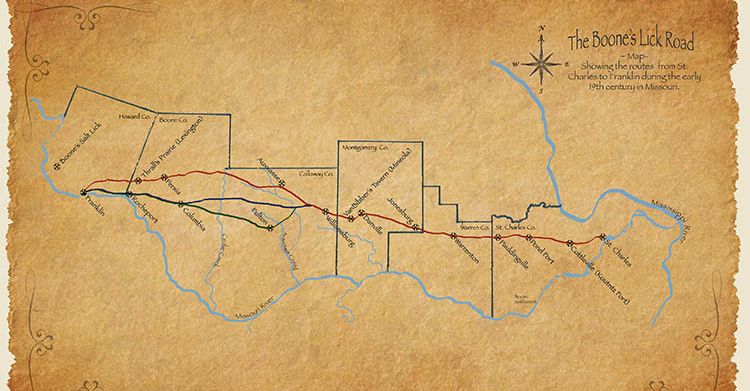
The original trail used by the Boone family in 1804 to reach their salt lick in Howard County, had already been used by the buffalo and the Native Americans for years before that. The expansion of Americans into the area had disrupted the original residents, and forced Native Americans tribes in the east to crowd into the Missississippi and Missouri River area in the early 1800s. This had caused the settlers to fear and be caught up in the depradations and raids on the settlements by 1812. Many of the early residents along “the Osage Trace” soon would be forced to Fort Up, or fortify their homes, in order to give them and thier neighbors safety. These early forts were not “Forts” in the traditional sense, as the military would erect for hundereds of soldiers, but homes where the windows were boarded up, and provisions stored in case of an attack.
Pond Fort was started by Robert Baldridge, a native of Ireland, who moved to Kentucky and then Missouri. The fort was said to be built in the form of a hollow square on land from a Spanish land grant. A single family there originally and the fort was given the name for a large pond two hundred yards away. This fort, as well as several others, were constructed on the lower Missouri in 1800. It was also a stopover for William Clark on his expedition along the Missouri River.The marker is located on the south side of Highway N, about two miles west of Highway 40-61.
On April 12, 1809, the Missouri Gazette, a newspaper published in St., Louis, Missouri stated “Lewis ordered all volunteer companies of cavalry, riflemen, and infantry in Upper Louisiana to hold themselves in readiness to march at a moment’s warning, and appointed a committee—Colonel Timothy Kibby, Major Daniel Morgan Boone, and James Morrison – to superintend the building of blockhouses from the Mississippi to the Missouri.”
Robert Baldridge (1737-1822) was one of the thousands of Scotch Irish Presbyterians who would emigrate from Ireland, and settle in Kentucky, which had been formed out of Virginia in 1792. One of the first settlers of what was to become St. Charles County, he’d married Hannah Beverly Fruit in Kentucky, and together they had James, Elizabeth, John, Daniel, Catherine, Malachi, Alexander, Grace, Nancy and Robert Junior. Their children would intermarry with several other of the earliest families; the Hoffmann, Zumwalt, Howell, Price, Scott, and Ryebolt families, among others.
Robert’s son Malachi and two of his companions, Price and Lewis, were killed while hunting on Loutre Prairie (today’s Montgomery County). Shortly after this event, Robert’s son Daniel, who wanted to avenge his brother’s death, tracked the party of Native Americans to their camp at night and attempted to shoot their Chief as he sat by the campfire. Daniel then concealed himself in the tall grass and watched while they searched for him; however, they failed to find him. Robert’s sons Robert Junior and John both served as rangers in Callaway’s company, during the War of 1812. The Baldridge family had established what was called Pond Fort, one in a series of private forts that formed a line of defense against the Native Americans by the settlers. The fort was built in the form of a hollow square and named for a pond, two hundred yards away.
In 1868 Historian Lyman Draper was talking with Major John Gibson who described the Ranger activities as follows:
In 1811 Nathan Boone raised a Company of Rangers for 12 months we went into Building forts in Different places over the country to keep the Indians from murdering our helpless women and children. We built Fort Howard, 17 miles from St. Charles; then we Built Capogri; then we built Buffalo, then Fort Mason; then we built fort Madison 24 miles above the mouth of Desmoines [sic] river; then we built prarai Deshain [sic] and Built forts over the country. We built Stouts Fort; we built one at Troy, then crossed over on the Missouri River to Bellefountain Below St. Charles; then fortified at St. Charles; then came to Pinkney; then we built a fort at Charette Village; then came to Louter Island and built Fort Clemson: then up to Cote San Dessein, built a fort there; then thence to Boon’s Lick, and Built Coopers fort; then to the Council Bluffs; then we Returned back to St. Charles commenced building forts out in the country from the Missouri River we built Pond fort; then we built Kennedy’s fort on Peruke [sic] Creek; we finished all those garrisons in the year 1812 and had our women and children out of danger of the wild Savages.
Sapp’s Mapping the Boone’s Lick Road cites historian Kate Gregg with:
It is at Pond Fort that the Stephen Long expedition joins the road on their way west. Having crossed the Missouri River from St. Louis on May 4, 1820, Capt. Bell reported that they “rode on 8 miles to Pond fort, situated on a prairie, this work of defence was erected during the late war by the scattered inhabitants of the country . . . it is constructed of logs and a square, whose sides are about 200 feet, having block houses at each of the angles, in the interior, and joining to the sides are erected cabins for the accomodation of families . . . . It stands on a quarter section of land belonging to Mr. Baily, he resides here and keeps excellent entertainment for travellers . . . .
Further up the Boone’s Lick Road (Today’s Hwy N in St. Charles County) sits the site of Rodman Kenner’s Tavern
[2480 West Hwy N, Foristell, MO 63348, USA is where Pauldingville now stands. The marker was dedicated on 21 October 1913.]
As we reach the edge of today’s St. Charles County, we have to remember that it was organized as one of the five original counties organized in 1812. By 1818, its territory was what comprises Montgomery, Warren and St. Charles, half of the six counties it crosses today. When Warren County was organized in 1833, St. Charles took today’s shape. However, when early settlers like Rodham (also known as Rodman) Frederick Kenner arrived this didn’t really matter. He’d been born in Virginia December 3, 1791, to Rodham and Jennie (Burke) Kenner who had served in the Revolutionary War. Rodham served in the War of 1812 in Virginia and earned a Land Bounty in Missouri. He married Elizabeth Johnson, in Virginia, prior to 1812, and they would come to Missouri in 1834, bringing four sons, George, William, Rodham and a twin brother Winder. They also brought an enslaved family with them, who had a son named Rodman Kenner as well. Elizabeth’s brother Charles M. Johnson came to Missouri in 1835 and would purchase the old Boone home and 680 acres from Nathan Boone on 24 January 1837. Boone then left St. Charles County and resettled in Ash Grove in Greene County.
Kenner was a first-class landlord, and his hotel became a noted resort and stage stop. He also played the fiddle so well he could almost make the “trees dance.” When he heard the stagecoach approaching or the dogs with their bark of welcome, would take his seat outside the door, his fiddle in hand and play Money Musk, Arkansas Traveler or some other lively tune. Kenner said the blessing at mealtime, ending with, “And for all these blessings we thank Thee, O Lord. Amen. Kick that blamed dog out from under the table.” Col. Thomas Hart Benton, one of Missouri’s first Senators, after stopping in the area visiting friends, commented on the good food and good beds. Many travelers would ride extra hard to make Kenner’s Tavern for the night. Kenner’s Tavern was also the location for sale auctions for the area’s enslaved individuals prior to the Civil War. Kenner made a fortune and died in 1876 at eighty-six years of age in what was by then called Pauldingville. He is buried in the small cemetery nearby which may be attributed to the early Pauldingville Baptist Church at that location. So ends our journey across St. Charles County along the Boone’s Lick Road.
[1] Melish, John. The Traveller’s Directory Through the United States: . . . John Melish: Philadelphia, 1822. 3 Peters, “Path of Land-Rush Traffic Across Boone and Callaway Counties,” Genealogical Society of Central Missouri Reporter Quarterly, vol. 13, no. 2 (Summer, 1994): 39. 4
SUBSCRIBE TO ST CHARLES COUNTY HISTORY BLOG BY DORRIS KEEVEN-FRANKE (FREE)


You must be logged in to post a comment.