
News of the Portage des Sioux treaties sent a message to residents of eastern states; it was now safe to emigrate and homestead in the Missouri Territory. From 1816 to 1820 settlers “came like an avalanche” wrote missionary John Mason Peck. “It seemed as though Kentucky and Tennessee were breaking up and moving to the Far West.” The treaties also had political ramifications. Missouri filed for statehood in 1820 and William Clark failed in his election bid to become the new state’s first governor. Voters viewed him as being “too soft” on the Indians at Portage des Sioux. Jefferson’s plan of coercion through commerce had worked, though not exactly as he envisioned it. The treaty of Portage des Sioux reaffirmed the process of depriving the Osage of their land and it opened the door for a flood of settlers who rapidly filled the old Osage domain and clamored for more. At the beginning of 1808 the Osage dominated nearly 1/8th of the Louisiana Territory but in just 17 years, they were left with a reservation only 50 miles wide and 150 miles long in southern Kansas. The Treaty of Portage des Sioux which meant peace to the United States only added to the change and turmoil being experienced by the Osage Nation.
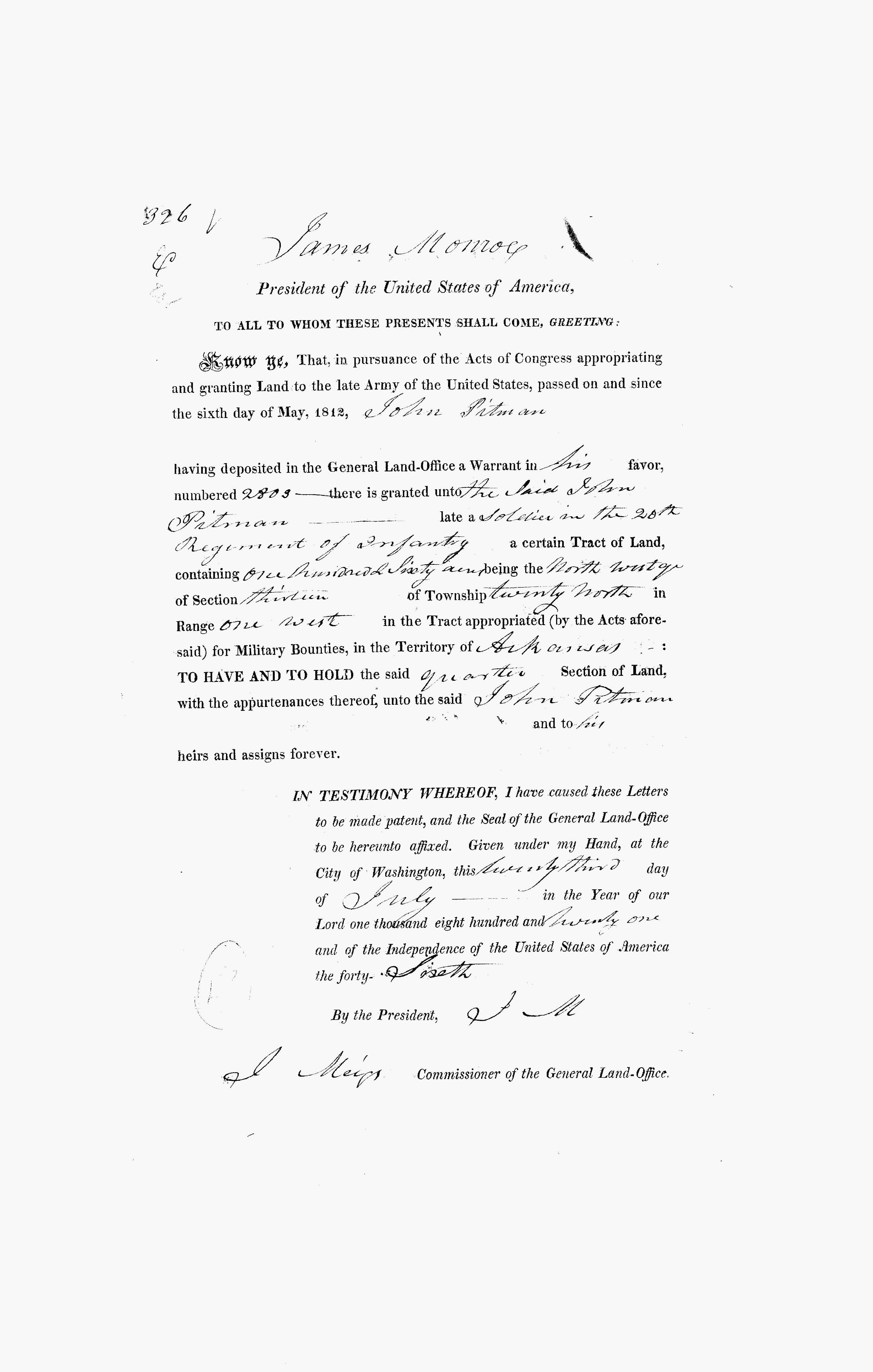
In 1816, John Pitman (1753-1839) and his neighbors would file a Petition, asking the Government to assign a surveyor to lay out a road to the most western edge of U.S. settlement at that time, called the Booneslick. That road would become today’s Boone’s Lick Road. In 1816, roads were named by where they were headed! As this old Buffalo trace, turned into a trail, it was because the population was growing. Veterans of the Revolutionary War, like Pitman, had been awarded Land Grants for their service. Pitman had moved to Missouri by 1816, bringing many of his family and his relatives with him. His brother Thomas Pitman (1750-1825) had settled at Howell’s Prairie, near the Missouri River.
Pitman’s Land Warrant was issued for land in the Arkansas Territory in 1821, but he had already moved his family to Missouri by that time. He sold that land warrant to a relative, using it to enlarge his amount of property here in St. Charles County. But in 1816, he was one of a growing number of St. Charles County residents that realized that the Territory was growing, and that good roads were important. And just like James Morrison on St. Charles’ Main Street, who owned the Bryan and Rose Salt lick at the other end of the Boone’s Lick Road, Pitman wanted to make sure that his land would be on “the big road” as it was often referred to at that time.
In 1818, U.S. Land Sales Offices had opened an begun selling land using the Public Land Survey System of a Section Range and Township, which Thomas Jefferson had encountered in France. When the U.S. purchased the Louisiana Territory from France in 1804, it didn’t come with any records of who owned what land already. Besides sending out the explorers Lewis and Clark, surveyors were needed to lay out these grids. With the War of 1812, that process would be interrupted. After the treaties, work would begin anew by surveyors. However, the U.S Land Office was also involved at the same time, in identifying who already owned what land. Early settlers like Daniel Boone, Warren Cottle and Jacob Zumwalt had already purchased land prior to 1804. These early land grants from the Spanish were called into question and they had to prove to the new government that they truly owned the property. There was also a lot of land speculation and those that tried to claim land that they didn’t actually owned. And there were those who didn’t own land, but had simply “squatted” on a parcel calling it theirs.
This was a difficult time, as we were just a Territory, and with little representation in D.C., and thoughts of Statehood were beginning. The demographics were changing as well, as the fur traders were giving way to those coming from the states of Virginia, Kentucky, and Tennessee buying up huge swaths of cheap land and bringing their cheap labor force, the enslaved, with them.
RESOURCES
For More about Missouri’s Land Sales and where to obtain records see the Missouri Secretary of State Archives website:
Follow links within our blogs and they will take you to previous posts that have more information. Or you can use the Search function below to search categories, tags, or previous posts.

3 responses to “Settlement begins”
Is there anyway I could have someone find out more about John Klingenschmidt Bell and his wife Barbara Crow Bell who were in Femme Osage Township on survey 1721?
When did he buy it or from what time did they live there?
I’m certain that, it is now currently the Klondike Park off of Highway 94.
Just was wondering if you could provide any documentation on that.
Thank you,
Daniel Westerhold
Get Outlook for iOShttps://aka.ms/o0ukef
LikeLike
You could try the St. Charles County Historical Society at 101 S. Main Street in St. Charles. They have lots of volunteers that are great at helping with requests like this!
LikeLike
Hey there Dorris,
I’m Daniel Westerhold. There are some tax records of John K. Bell Sr. and his wife Barbara (Crow) Bell who lived there on Survey 1721 in St. Charles County. He is listed along side Daniel Boone in the Femme Osage township as well.
There’s also records of his service in the War of 1812 with Captain Joseph Connaway/Conway.
According to the Our Bells of St. Andre’ Del Misuri book, written by Weir and Ethel Bell, https://www.familysearch.org/library/books/records/item/353976-our-bells-of-st-andre-s-del-misuri-1794-1994
John K. Bell Sr. moved north of the “river” from their parents Spanish Land Grant 909 off of Wild Horse Creek Road. That property is on the western county border of St. Louis County and Eastern border of Franklin County, southern border to the Missouri River.
The evidence of John K. Bell’s land it St. Charles County, lies in Matson, MO at the old Daniel Boone Judgement Tree.
https://www.google.com/maps/place/Daniel+Boone+Judgment+Tree+Memorial/@38.6089495,-90.7943135,3a,75y,90t/data=!3m8!1e2!3m6!1sCIHM0ogKEICAgIC8mMSf_gE!2e10!3e12!6shttps:%2F%2Flh3.googleusercontent.com%2Fgps-cs-s%2FAC9h4npF1nXblMhXrBWC8aZhl_HunsHwKl1FufWAFhQzR6DfW_4YQ_uwdFxTp2vabeSum_rYVdwzfRYdRC3p-WQmqDEa28MXEXM7AHjTN8bLlR3enDBQJ2-rpnZ_2zxWE3BMVsnNbTOkFw%3Dw203-h152-k-no!7i4032!8i3024!4m15!1m7!3m6!1s0x87d933aa75446f8f:0x1363bc825fa264cd!2sKaty+Trail+-+Matson+Trailhead!8m2!3d38.6084515!4d-90.7948455!16s%2Fg%2F11g8t_b13v!3m6!1s0x87d9330084299db9:0x50886f4f60a11478!8m2!3d38.6088115!4d-90.7940078!10e5!16s%2Fg%2F11hd1rxn__?entry=ttu&g_ep=EgoyMDI1MDkxNy4wIKXMDSoASAFQAw%3D%3D
This map made by Ken Kamper, a Daniel Boone expert historian, and co-researcher to Weir and Ethel Bell genealogy for their book, clearly shows the brother to Barbara (Crow) Bell. She clearly made a plea to her husband after her father-in-law’s passing of unknown reasons at an early age of 52, I believe, and the death of John’s Mother’s cousin, John Ridenhour, to move to be closer to her parents and her family.
Just two neighboring properties away was her brother, (Henry Crow) on the eastern edge of Augusta, Missouri. Beyond Henry’s property is her other brother John Crow. Also in the general area was her brother Lewis Crow, who I recall made it to the rank of Sergeant Lewis Crow, who if I recall was under the command of Captain James Callaway, grandson to Daniel Boone, son to Flanders Callaway, who were nearby neighbors to John K. Bell Sr. and Barbara (Crow) Bell.
What year he moved there is unclear to me. I’d guess sometime between 1803-1805. I know that there was a flood in 1808 that washed away the town of St. Andre’ (Andrew.)
So, look to the Crow family’s genealogy for help on this one. I think you’ll agree that this was a move on behalf of this wife. I don’t remember where I found the tax records, but he is on a few of them, listing him on the 1721 survey. Klondike park’s border map on top of the trail matches and fits the location of Survey 1721. The Army Corp of Engineers redirected the Missouri River to go right through the middle of the long narrow strip of land going in a southwest direction towards Labadie powerplant. I believe John’s land goes right up to, or along the Labadie powerplant.
I may have more information on this posted on my Facebook page, titled the same as the book. Our Bell’s of St. Andre’ Del Misuri.
Daniel Westerhold
LikeLike