May 20, 1804 “The clouds continued to follow each other in rapaid succession, insomuch that there was but little prospect of it’s ceasing to rain this evening; as I had determined to reach St. Charles this evening and knowing that there was now no time to be lost I set forward in the rain, most of the gentlemen continued with me, we arrived at half after six and joined Capt Clark, found the party in good health and sperits. suped this evening with Charles Tayong a Spanish Ensign & late Commandant of St. Charles at an early hour I retired to rest on board the barge— St. Charles is situated on the North bank of the Missouri 21 Miles above it’s junction with the Mississippi, and about the same distance N. W. from St. Louis; it is bisected by one principal street about a mile in length runing nearly parrallel with the river, the plain on which it stands—is narrow tho’ sufficiently elivated to secure it against the annual inundations of the river, which usually happen in the month of June, and in the rear it is terminated by a range of small hills, hence the appellation of petit Cote, a name by which this vilage is better known to the French inhabitants of the Illinois than that of St. Charles. The Vilage contains a Chappel, one hundred dwelling houses, and about 450 inhabitants; their houses are generally small and but illy constructed; a great majority of the inhabitants are miserably pour, illiterate and when at home excessively lazy, tho’ they are polite hospitable and by no means deficient in point of natural genious, they live in a perfect state of harmony among each other; and plase as implicit confidence in the doctrines of their speritual pastor, the Roman Catholic priest, as they yeald passive obedience to the will of their temporal master the commandant. a small garden of vegetables is the usual extent of their cultivation, and this is commonly imposed on the old men and boys; the men in the vigor of life consider the cultivation of the earth a degrading occupation, and in order to gain the necessary subsistence for themselves and families, either undertake hunting voyages on their own account, or engaged themselves as hirelings to such persons as possess sufficient capital to extend their traffic to the natives of the interior parts of the country; on those voyages in either case, they are frequently absent from their families or homes the term of six twelve or eighteen months and alwas subjected to severe and incessant labour, exposed to the ferosity of the lawless savages, the vicissitudes of weather and climate, and dependant on chance or accident alone for food, raiment or relief in the event of malady. These people are principally the decendants of the Canadian French, and it is not an inconsiderable proportian of them that can boast a small dash of the pure blood of the aboriginees of America. On consulting with my friend Capt.C I found it necessary that we should pospone our departure untill 2 P M. the next day and accordingly gave orders to the party to hold themselves in readiness to depart at that hour.—
So writes Captain Meriwether Lewis in his journal entry for May 20, 1804. Definitely one of the earliest descriptions of St. Charles. Charles Tayong is actually Don Carlos Tayon, the former Commandant, that had been replaced by James Mackay. Describing our Main Street of about a mile long, that is actually the distance from Mackay’s home to its’ intersection with Jefferson St. This entry tells us that there are at least one hundred homes at that time, and a population of about 450 residents. There is a chapel, and a priest, which is today’s St. Charles Borromeo Catholic church . It is all elevated enough to keep it from flooding much, as the hillsides called petit Cote which means Little Hills in French, are what the area is generally known as. “These people are principally the decendants of the Canadian French, and it is not an inconsiderable proportian of them that can boast a small dash of the pure blood of the aboriginees of America” implies that a portion of the residents owned enslaved people. The journal entry is documentation, and a snapshot, of St. Charles in 1804, as we joined the United States as part of the Illinois Territory. The departure of Captains Lewis and Clark from St. Charles is one of the most important moments in our history.

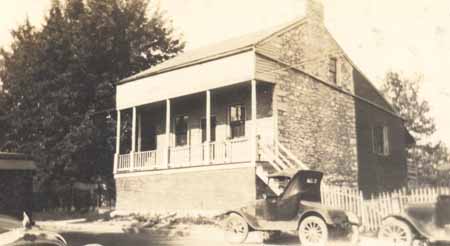
The stone portion of the building is the home of James Mackay, Commandant of the Illinois Territory in 1804. It stood at 1017 South Main Street. “This is the site of the headquarters of James Mackay (sometimes referred to as Don Sanitiago Mackay) who was the Commandant for St. Charles from 1802-1804. The original building had been built of Burlington stone in 1797. When the Spanish appointed him to replace Carlos Tayon, his home was at today’s Chesterfield, across the Missouri River and west of St. Charles. A former explorer and fur trader, Mackay had led expeditions up the Missouri River creating the map that Lewis and Clark would later use for their famous 1804 expedition. In 1804, though aware of all the political negotiations of the time, for the Louisiana Purchase, Mackay would defy instructions by his Spanish government to block the expedition. Instead he met and conferred with its leaders. No doubt it was Mackay’s prescence that was one of the reasons that attracted the Corps to consider St. Charles their starting point.” [See Historic Main Street Tour https://storymaps.arcgis.com/stories/ef8dfd89425c46349ead22cd80213320]

You must be logged in to post a comment.