Heading westward from St. Charles on the Boone’s Lick Road, one left the village heading west and would pass Old Man Schaffer’s Tavern [on Parkside, today it is a private home and still standing, but there is no marker] who served the needs for those driving their stock to market. Friedrich Schaeffer was a German immigrant who hadmost likely read the Report on a Journey to the Western States of America, published in Germany by Gottfried Duden in 1829 which extolled the virtues of the young state of Missouri. Like thousands who came during the 1830s, the German immigrants would not only change the state’s demographics but its’ history as well. Schaeffer’s Inn was a favorite for those needing a watering hole for their cattle, outside of the town’s limits on what was formerly the Commons. City ordinances did not allow cattle and hogs to roam the streets.
[Proceeding further on Boone’s Lick, turn left/south on Missouri’s State Highway 94/First Capitol and proceed to Mid-Rivers Exit. Turn right/west on Mid-Rivers and proceed until the intersection with County Highway N. Turn left on Highway N ]
COONTZ’ FORT
BOONE’S LICK ROAD MARKER – BY THE DAUGHTERS OF THE AMERICAN REVOLUTION AND THE STATE OF MISSOURI IN 1913 KOUNTZ’ FORT at 4965 Highway N on your right hand side.
Two Coontz brothers had been born in Germany and had perhaps served in the Hessian Militia for the British Army during the Revolutionary War, but defected and joined the colonists. One brother had been captured by the Native Americans and had been presumed dead. The other would come further west and settle in St. Charles purchasing Blanchette’s property from his estate. The first brother had learned of the others whereabouts and joined him in what was then Louisiana Territory. Nicholas Coontz would acquire Survey #58 on 29 Aug 1799. His log home was large enough and well-built and would be fortified to serve as a Fort, for the protection of many of the area families during the War of 1812. He kept a tavern, and in the Memoirs of John Mason Peck, D.D., 1789-1857 he was described as “a rough, wicked and yet hospitable old German”.

PROCEED SOUTH ON HWY N TO COTTLEVILLE, IT IS IMPORTANT TO STAY ON HWY N AS IT MAKES SEVERAL TURNS THROUGH COTTLEVILLE.
COTTLEVILLE
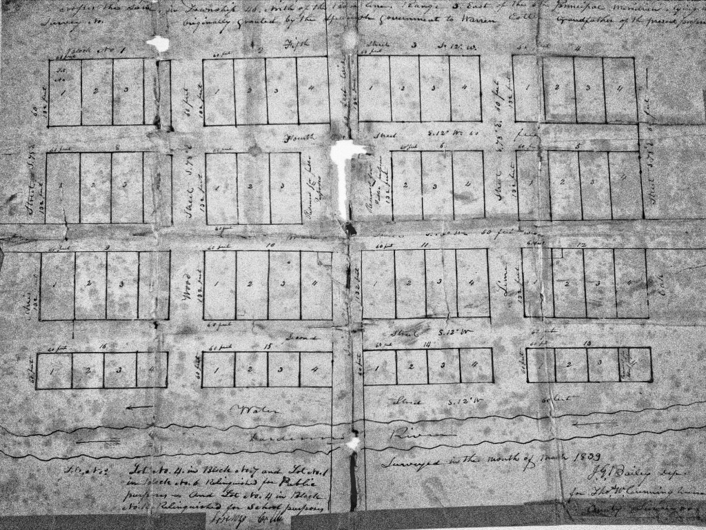
Cottleville’s history as a settlement begins with the occupation of Warren Cottle, Sr. on a plot near Dardenne River (Creek), obtained through Spanish land grants in 1798. Together, with his sons, Warren and Ira, Cottle began a grist mill on the Dardenne River (Creek) in 1799. Cottle’s Mill used waterpower to sift and grind wheat, oats, and other products. The water method proved to be superior to the other horse powered mills found within the area and many people began to bring their harvested crops to Cottle’s Mill. Over the next decade, the large number of customers encouraged the establishment of small shops and lodges to accommodate those waiting, sometimes overnight, for their turn at the mill. The mill was one story high. The power for the mill came from an overshot wheel on the left side of the drop and it had wooden gears. The driving gear had all wooden cog wheels and the frame mill was one story high.[i] In 1837, Cottle would file a plat of his town with the St. Charles County Recorder of Deeds, making it official.


SOURCES
[i] Sheryl Guffy, Cottleville Legacy https://cottleville.org/
FOR MORE ABOUT THE BOONE’S LICK ROAD SEE https://booneslickroad.org/
SUBSCRIBE TO STCHARLESCOUNTYHISTORY.ORG (FREE) AND RECEIVE DAILY EMAILS BY DORRIS KEEVEN-FRANKE

You must be logged in to post a comment.