
Everyone loves old maps. Maps can do a lot more than give directions. Historic maps can share what a place looked like at a certain point in time and transport us back. There are some maps can do more than all of this, they can share a story as well. This is the story of a map that takes people back in time, to the City of St. Charles historic past, all the way back to its’ beginning.
It took me back to the City’s beginning. In 2010, when I began working as archivist for the St. Charles County Historical Society, I discovered a crinkled and faded old map. The secretary at that time, Cleta Flynn, was introducing me to some of the more reclusive collections tucked away in corners of the archives and had said “if you like old maps, this large map case has a lot of interesting old ones.” Buried in amongst several other interesting items, was one that was taped, creased, folded and flattened (something us archivists hate) and that appeared to have not seen daylight in a hundred years – which was good for the map – but also rather sad.
Keeping the old map handy for the next few years, it would be used for study from time to time by myself, and several of the volunteers. Trying to unlock its secrets, the map did not appear to have any date on it, nor did it have a signature to recognize who had drawn this treasure trove of information. Realizing it was a map of St. Charles, and that it was old (which could also be recognized by its ink and paper) we became determined to learn more. It was old, but just how old? And who had drawn it? And why? What was its’ purpose and who was the information for? This wasn’t a map for directions.
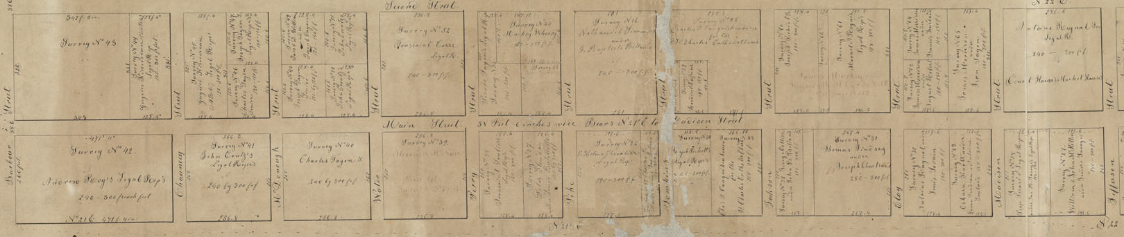
The map clearly laid out St. Charles as a grid of streets and cross streets, giving just their names. The street names were old and historic themselves, such as Barbour, Chauncey, Pike and Clay, names that meant something in the early 19th century when St. Charles was just a village. Over the years we would pull the map out whenever a researcher needed information about very early St. Charles. The names of the owners in each of these blocks became very important, as that seemed to be the purpose of the map. It became obvious that if we were to know just when the map was made, perhaps knowing more about when these were the owners, we could possibly discern a date. And so every time we were able, we used the map, taking great care.
Then one day a local researcher came in working on these families, who had done some very careful research on these early families. Finally we were able to pin the map down to the era of circa 1817-1822, with his help. This is when it became apparent that this was a vital component to our City’s history. Discussing this with our Local Records Field Archivist Bill Glankler and Lisa Fox, at the State Archives was my next step. Evaluating the authenticity, the condition of the map and its importance, was their next step. It was then decided that this should be something submitted to them for conservation and preservation. Lisa Fox, Head Conservator at the Missouri State Archives, Mike Everman, in St. Louis, and Bill Glankler coordinated everything. Fox’s wonderful team worked their magic, carefully removing the old tape, creases, and even the dirt to reveal a more magical piece of history. The map, approximately fourteen by seventy-two inches was then digitized in order to enable everyone to delve into its history. The State Archives also retained a digital scan of the map thereby enabling everyone access to this historic treasure.
Because of this great work, the map is carefully preserved, yet made available to everyone. Since then, I wanted to know more of the maps other great mysteries. Who was its’ creator and why? What stories does this map share? That has been quite a journey as well, leading to all kinds of wonderful new discoveries of St. Charles and its history. Sometimes, when trying to discover the stories found in old documents and maps, you have to travel to the time in which the people lived. This map does help one to do that.
For clues to its’ history one has to look at what information is shared and the purpose. This map provides a) the layout of streets, their names, and measurements; b) names inside some of the blocks formed by that grid; c) the dimensions of the blocks in the old French Foot measurement; and a survey number of that block of land. The names of the streets running north and south and parallel to the Missouri River are Main, Second, High and Fourth. The cross streets (these run east-west) run from Barbour, which is the original southern city limits to Tecumseh Street on the north. The Missouri River is not shown, neither is the Boone’s Lick Road, nor any buildings, landmarks or terrain. This map was probably made by Benjamin Emmons (the first) to start and establish who was where in St. Charles.
Enter your email for a free subscription to a daily email with St. Charles COUNTY history! Share with your friends… they will thank you for it!

You must be logged in to post a comment.